Probably best known as the land you drive over after crossing the Memorial Bridge, or as the home of the World War II battleship USS North Carolina, Eagles Island holds a far more significant place in our regions history than most people are aware. And now, with the formation of a newly formed local group, there are plans for the entirety of the island to be preserved as a “Central Park” for our region.
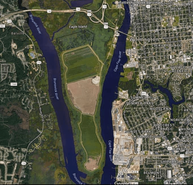
Eagles Island gets its name from Richard Eagles, an English native, merchant, and planter who came to the area from Charleston, South Carolina, in 1734. It spans approximately 3,110 acres, with the majority of the land in Brunswick County except for a portion of the eastern shore that is located in New Hanover County, and is bounded by the Brunswick River to the west and the Cape Fear River to the north, east, and south.
One of the most interesting features of Eagles Island is that is has been formed by both natural and human influences over time. The southern tip of the island has been shaped almost exclusively by dredging deposits from the US Army Corps of Engineers, creating important migratory bird habitats. In addition to the unique plants and animals found there, Mother Nature has shaped the island over millions of years of weather events, which now includes the challenge of climate change and rising sea levels.
Eagles Island has long been a fixture for the inhabitants of the lower Cape Fear region. The stories begin with the hunting and gathering of the regions Native American tribes, and include the history of the naval stores and ship building industries that were located there centuries ago, the shipwrecks and archaeological treasures littering the eastern shore, and culminate with the rice and indigo cultivation of the Gullah people who fled the island after the insurrection of 1898.
Conservation efforts for Eagles Island began in 2002 with an unsolicited donation of 53 acres to
the New Hanover Soil & Water Conservation District, which triggered further acquisitions by the District and the Cape Fear Resource Conservation who proceeded to purchase over 500 acres of land on the island. In response of this effort, the Eagles Island Coalition was formed in late 2010 to move beyond the task of acquiring individual properties and towards an integrated approach of working with private and public stakeholders for the holistic conservation of Eagles Island.
On the back of the massive work that has already been accomplished, recently a group of us have formed the Eagles Island Central Park Task Force in an effort to bring the vision of maximizing the public benefits of the islands resources towards the possibilities of recreation, education, and preservation to reality. The consortium of individual, corporate, and governmental stakeholders in Eagles Island make for a challenging collaboration of interests, but also a fitting exercise in the regional cooperation that is required to do great things.
Given the unique and important history of Southeastern North Carolina, the need for more recreation for our growing population, and the inevitable development of much of our regions natural lands, now is the time to recognize the extraordinary opportunity at hand. But this vision will not happen for us, it will happen because of us.
Turns out that the story of Eagles Island has yet to be written, and we are the ones we have been waiting on. Join the effort by following our FaceBook page at:
http://fb.com/eaglesislandcentralpark.
Evan Folds is an elected Supervisor of the New Hanover Soil & Water Conservation District serving as co-chair for Eagles Island Central Park Task Force with Lloyd Singleton, director of the N.C. Cooperative Extension, New Hanover County center at the Arboretum. Reach him at [email protected] or 910-798-7660. The Arboretum, located at 6206 Oleander Drive is free and open every day from 8 a.m. to 5 p.m.
* Permission to reprint this article granted by Lloyd Singleton, Director, Cooperative Extension, New Hanover County.


